History of Dokdo
About the History of the Dokdo Island
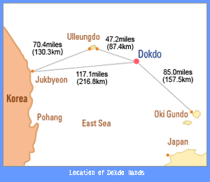
Historically, Dokdo has been part of Korean territory since 512 (the 13th year of the reign of Silla King Jijeung), when Silla absorbed Usanguk. This fact is recorded twice in Samguksagi (The History of Three Kingdoms, 1145): Volume 4 Sillabon-gi (Silla’s records) and Volume 44 Yisabujeon (The Biography of Yi Sabu). Usanguk included Ulleungdo and Usando (called Matsushima in Japan before 1880) when it was absorbed by Silla, which is recorded in a number of ancient texts including Sejongsillokjiriji (Gazetteer of the Annals of King Sejong, 1454) published in 1481; Sinjeungdonggukyeojiseungnam (Augmented Survey of the Geography of Korea) published in 1530; Man-giyoram (Guidebook of State Affairs, 1808); and Jeungbomunheonbigo (The Augmented Reference Compilation of Documents, 1908).
After Japan plundered Ulleungdo, incurring heavy human casualties, King Taejong of the Joseon Dynasty (1392-1910) ordered the residents of Ulleungdo be brought to the mainland in 1417, under an “empty island” policy that prohibited people from residing on the islands due to concerns for their safety. This “empty island” policy for Ulleungdo was then repealed in 1883 when King Gojong implemented a resettlement policy and allowed residents to return to the island. In 1849, the French whaler Liancourt, after observing and surveying Dokdo, named the island group after their ship, calling them the Liancourt Rocks. After this, many Western maps and geography texts identified Dokdo as the Liancourt Rock Islands.
According to the Japanese government, the first Japanese text to mention Dokdo is Onshushichogoki (Records of Observations of Onshu, 1667). However, according to this text, Dokdo (called Matsushima in Japan at that time) and Ulleungdo (called Takeshima in Japan at that time) were part of Goryeo territory, with Japan’s northwestern limit being clearly delineated as Oki Island, thus confirming that Dokdo and Ulleungdo were part of Korean territory.

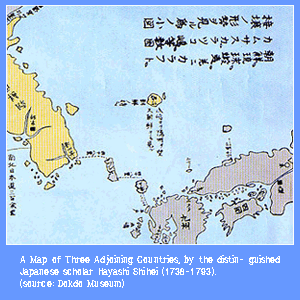
During the Edo period (or Tokugawaperiod ,1603-1867), Japan recognized and respected the fact that Ulleungdo and Dokdo were part of Joseon territory. For example, the distinguished Japanese scholar Hayashi Shihei (1738-1793) produced two maps, “Sangokusetsuchizu” (A Map of Three Adjoining Countries, 1785) and “Nihontaigokuchizu” (A Map of the Japan Empire), in which he identified national boundaries and territories by using different colors for each nation, yellow for Joseon and green for Japan.
He placed Ulleungdo and Dokdo at their proper locations and not only colored them yellow, but also noted “Belonging to Joseon” next to the islands, clearly recognizing them as Joseon territory.
In addition, in 1876, the Department of the Interior of Japan’s Meiji government ordered each prefecture to draw a map of its territory for a national geographic survey and map production initiative. At this time, the governor of Shimane Prefecture asked the Department of the Interior whether Takeshima (Ulleungdo) and Matsushima (Dokdo) should be included in the Shimane Prefecture map and geographical survey. After spending a little over five months researching materials related to Ulleungdo and Dokdo, such as documents that had been passed back and forth between Japan and Joseon at the end of the 17th century, the Japanese Department of the Interior concluded that Takeshima and Matsushima were Joseon territory and were thus “of no concern to Japan.”
…………………………………………………………………..
독도의 역사
동도와 서도 사이의 해협

역사적으로 독도(獨島)가 한국의 고유 영토가 된 것은 삼국시대인 서기 512년(신라 지증왕 13년) 우산국(于山國)이 신라에 병합된 때부터다.
이 사실은 三國史記(1145)의 두 곳, 권4 신라본기 지증왕 13년조와 권44 열전4 이사부(異斯夫)전에 기록되어 있다.
이때 신라에 병합된 우산국 영토가 울릉도와 함께 우산도(于山島)(일본에서는 1880년 이전에는 마쓰시마[松島]라 부름)로 구성되어 있었음은 세종실록지리지(1454), 신증동국여지승람 (1530년 편찬) 만기요람(1808), 증보문헌비고(1908) 등 다수의 고문헌에 기록되어 있다.
일본이 울릉도에 노략질을 자행하여 인명피해가 컸으므로 조선의 태종은 1417년에 울릉도의 주민을 모두 육지로 소개하고 울릉도와 우산도(독도)에는 공도(空島)정책을 실시했다.
공도정책이란 영유권은 갖되 주민의 안전 등을 고려하여 그 섬에 사람의 상주를 금지시키는 정책이었다.
그러나 공도정책은 1883년 고종이 울릉도 재개척 정책을 채택 실시하여 주민을 다시 이주시키면서 폐기되었다.
한편 1849년에는 프랑스의 포경선 리앙쿠르호가 독도를 관찰 측정한 후 그 배의 이름을 따서 독도에 ‘리앙쿠르암(岩)'(Liancourt Rocks)이라는 이름을 붙였다. 이후 대부분의 서양의 지도와 지리서에서는 독도를 “리앙쿠르암도(島)”라고 표시하는 일이 많아졌다.
일본측에서 최초로 독도를 인지한 고문헌은 1667년에 편찬한 은주시청합기(隱州視廳合記) 라고 일본정부는 밝히고 있다.
그런데 이 고문헌은 독도(당시 일본 호칭 마쓰시마)와 울릉도(당시 일본 호칭 다케시마)는 고려 영토이고, 일본의 서북쪽 경계는 오키섬[隱岐島]을 한계로 한다고 명확히 밝혀서, 독도와 울릉도가 한국 영토임을 명확히 밝혔다.
그 후에도 시대(또는 도쿠가와시대 1603-1867)의 일본은 울릉도와 독도가 조선영토라는 사실을 잘 인지하고 존중하였다.
예컨대 일본의 대학자 하야시 시헤이(林子平, 1738~1793)는 1785년에 제작한 “삼국접양지도(三國接壤之圖)”와 “대일본지도(大日本地圖)”에서, 국경과 영토를 나타내기 위해 나라별로 채색하면서 조선은 황색, 일본은 녹색으로 표시했다.
이때 하야시 시헤이는 울릉도와 독도를 정확한 위치에 그려 넣고 조선의 색깔인 황색을 칠했을 뿐 아니라, 울릉도와 독도 두 섬 옆에 조선의 것(朝鮮ノ持ニ) 이라는 문자를 적어 넣어 울릉도와 독도가 조선 영토임을 거듭 명백히 표시하였다.
또한 일본 메이지 정부의 내무성은 1876년에 전국의 지적조사와 지도제작을 위해 각 현에 자기 현의 지도를 작성해 보고하도록 지시했다. 이때 시마네(島根)현 지사는 다케시마[竹島]와 마쓰시마[松島]를 시마네현의 지도와 지적조사에 포함시킬 것인가 여부를 내무성에 질의하였다.
일본 내무성은 17세기말 조선과 왕래한 문서 등 울릉도와 독도 관계자료를 5개월 남짓 조사한 후, 다케시마와 마쓰시마는 조선영토이므로 일본과 관계가 없다고 결론 내렸다.
by Shin Yong-ha, Professor of Social History, Seoul National University
…………………………………………………………………………………………………………………………………………………………………………..
Reference :
http://dokdo.mofa.go.kr/eng/
http://dokdo.mofat.go.kr/
http://www.dokdohistory.com/main.do
http://www.thegrapevinetimes.com/TGT_e_news/e_news/2012/cbboard.php?page=tgt_event_dokdo&ddid=1
……………………………………………………………………………………………………………………………………………………………………………….
|
|
